Just after 4 p.m. on Nov. 11, 2026, the three-story building at 1321 Flatbush Avenue fell into the open excavation next door. The first 911 call came at 4:01 p.m. Eight people were killed, including two children and two construction workers. Eighteen were injured, four of them firefighters. Rescue operations ended the following afternoon.
The building had stood since 1930: a store at street level, four apartments above, five units in the parcel record. Next door, at 2625 Bedford Avenue, a one-story commercial building had been demolished and the lot was being excavated for a new development. The two parcels share a lot line. On the site map below, 1321 is the narrow dark-red bar; 2625 is the large hatched lot directly north.
The cause of the collapse is still under investigation. The public record does not answer why the building fell. It does show what was proposed, what was approved, what inspectors cited, and which questions the file leaves open.

Two parcels, one lot line
| Address | Parcel ID | Owner of record | Built | Stories / units | Building area |
|---|---|---|---|---|---|
| 1321 Flatbush Ave | 3-05211-0073 | Isolag Realty Corp | 1930 | 3 / 5 | 3,075 sq ft |
| 1323 Flatbush Ave | 3-05211-0072 | 1323 Flatbush Ave LLC | 1930 | 3 / 5 | 3,075 sq ft |
| 2625 Bedford Ave | 3-05211-0074 | FF1632 LLC | 1933 | 1 / 1 | 6,000 sq ft |
Source: landstats parcel layer. Building area is the parcel record’s building square footage, not the lot area. Addresses link to their parcel reports on the Landstats portal.
The geometry matters. 1321’s Flatbush Avenue frontage is its short, 20.5-foot edge; the building extends about 60 feet east, away from the street. That long east-west wall is the wall that faced the excavation at 2625. The site map is drawn from parcel geometry, not a news graphic: 2625 sits north of 1321, with 1323, 1325 and 1327 stepping south along Flatbush.
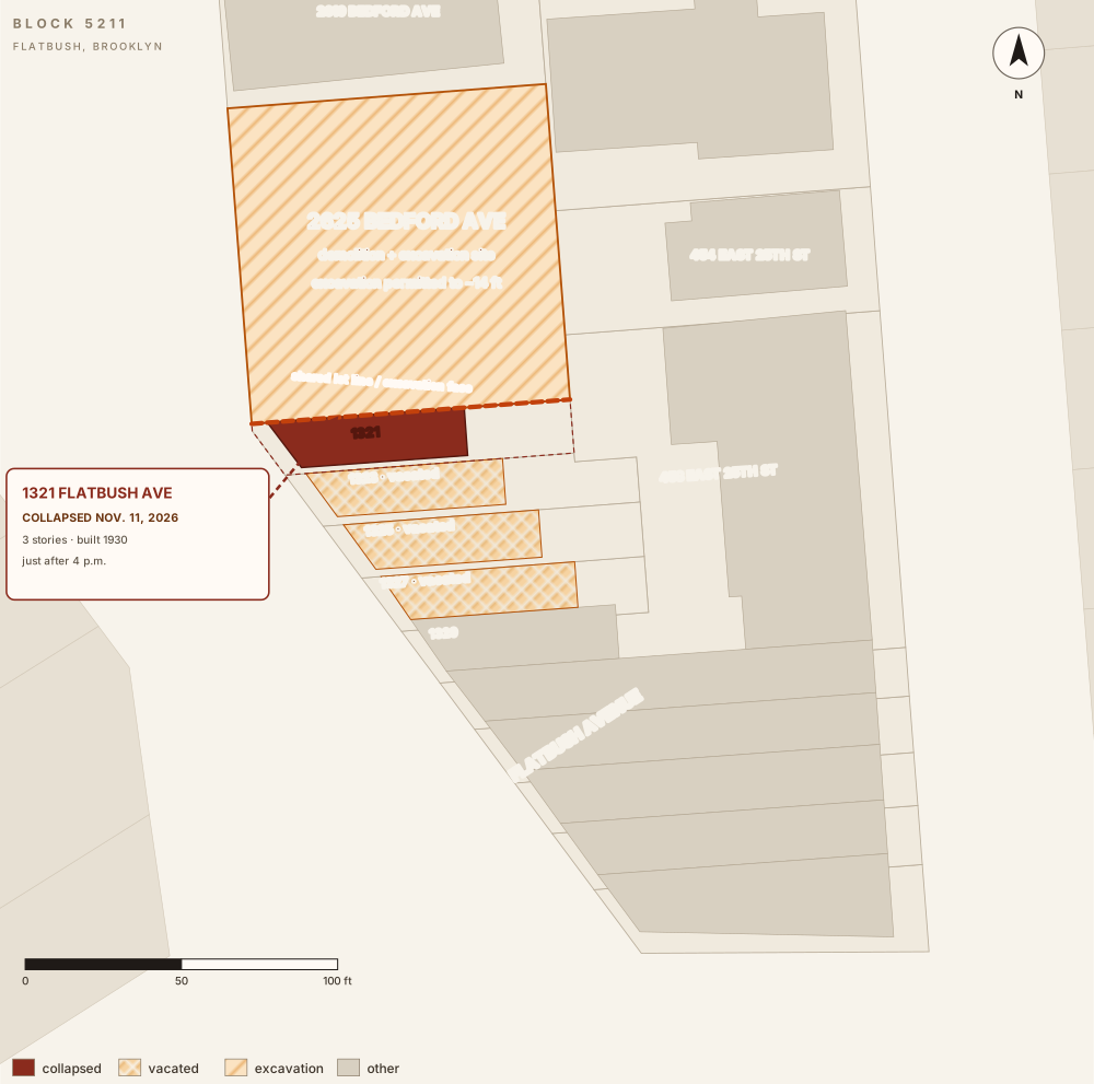
The parcel table lists 2625’s owner as FF1632 LLC. The construction filings name W6 Facility X LLC, with Robert Fischman as owner. The difference is a useful reminder: parcel data and permit data are different snapshots, and joining them is not the same as proving who controlled a site on a given day.
The lot next door
The 100-by-100-foot lot at 2625 sold on June 7, 2024 for $3.99 million, according to trade records. A full-demolition job was filed on Nov. 6, 2025 and approved on Feb. 2, 2026. The permit was issued Mar. 13, renewed May 8, and signed off Jun. 8. The scope was a one-story building; the filing put the cost at $140,000.
The demolition plan required overhead protection for adjacent properties at exposures #2, 3 and 4. That requirement became the first enforcement case: on Mar. 20, 2026, an inspector wrote that demolition had started and the protection was not installed. The ECB case, 39552071X, was a Class 1 violation; $2,500 was imposed and paid.
A second Class 1 case followed on Apr. 23. Inspectors compared current photos with photos from Mar. 20 — when a one-story building was still on the site — and concluded that work had continued while a stop-work order was in effect. ECB 39553409Z carried a $10,000 penalty, which the record shows was paid. Both cases are marked resolved. The city later said the problems were corrected and the stop-work order was lifted in May. Officials have not linked the demolition violations to the collapse.
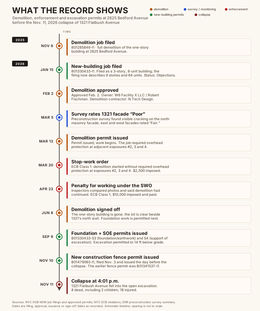
The permit record also shows how close the paperwork ran to the collapse. A new construction-fence permit, B01479063-I1, was filed Nov. 3, approved Nov. 9, and issued Nov. 10 — one day before the building fell. The earlier fence permit, B01341537-I1, had been issued in March.
The building that was proposed
The new-building application is where the record becomes harder to read. B01330433-I1 was filed Jan. 15, 2026. The version now in DOB NOW describes a nine-story, 64-unit, 71,388-square-foot mixed-use building with a cellar; the architect is Cheng-Yi Lin Architecture. Its status is Objections, with a latest action date of Sep. 29, 2026.
A Marketproof report on the initial filing described something smaller: a three-story, eight-unit building, 39 feet tall, with about 16,500 square feet of residential and commercial space. The filing date, owner and architect match. The application now on file describes the larger scheme.
The city’s account adds another piece. Buildings Commissioner Ahmed Tigani said the site had a plan approved for a three-story building, while the current nine-story plan had not been approved. The public filing record we retrieved shows one new-building application, B01330433-I1, filed Jan. 15, 2026 and now describing nine stories; its status is Objections. The record does not include the approval history that would show when — or whether — the three-story version was approved before the application was revised. We are flagging that gap, not resolving it.
What is clear is that the foundation and excavation subplans are filed under the nine-story job, while the city says the approved scope was three stories. The foundation and earthwork subplan, B01330433-S3, was approved Jun. 4 and issued Sep. 9. The support-of-excavation subplan, B01330433-S4, was approved Mar. 23 and issued Sep. 9. Both expire Jan. 5, 2027. Townhouse Builders Inc, with Mordechai Waisbrod, is the permittee and general contractor on both. A plumbing subplan was approved Sep. 30; the sprinkler and mechanical subplans remain in Objections.
| Role | Entity named in the record |
|---|---|
| Owner / permit applicant | W6 Facility X LLC; Robert Fischman |
| Parcel owner of record | FF1632 LLC |
| Demolition contractor | N Tech Design of America (Aramis Brown) |
| Demolition engineer | H & O Engineering DPC |
| Architect | Cheng-Yi Lin Architecture |
| SOE and foundation engineer | LMW Engineering Group LLC (Jieming Wang) |
| General contractor | Townhouse Builders Inc (Mordechai Waisbrod) |
| 1321 owner | Isolag Realty Corp |
Sources: DOB NOW job filings, approved permits and ECB records. The parcel and permit records use different owner names for 2625; that is a records mismatch, not evidence of anything beyond it.
What the excavation plan required
The engineering record is the most detailed part of the file — and the part that most clearly stops short of an answer.
The excavation was permitted to extend up to 14 feet below grade. A geotechnical report said buildings abutting the property line would require underpinning and warned that excavation and construction vibration could adversely affect adjoining structures. It recommended movement, crack and vibration monitoring.
A required preconstruction survey, performed Mar. 5, documented visible cracking at 1321 and rated its north masonry facade — the wall facing the excavation — “Poor.” The east and west facades were rated “Fair,” also with visible cracking. The survey said detailed information about the building’s foundation type and other structural features had not been provided.
The approved support-of-excavation drawings prescribed steel soldier piles, timber lagging, walers, rakers and concrete deadmen, with tangent piles at portions of the perimeter. The sequence called for piles before excavation; lagging in lifts of no more than 2 feet as digging advanced; and walers, rakers and deadmen before excavation reached final subgrade. Reviewers asked how soil loss would be controlled; the engineer said dry pack would be used, with a maximum 6-foot lagging span.
The plans also set monitoring thresholds. Baseline readings were to be taken before excavation, with optical surveys at least weekly. Crack gauges were to be installed on existing cracks in neighboring buildings, and vibration monitors near active work. Movement of 1/4 inch required immediate notification; 1/2 inch required work to stop until remedial measures or modified procedures were approved. Vibration above 1/2 inch per second required notification; above 3/4 inch per second, or a crack-gauge reading above 2 millimeters, required a stop.
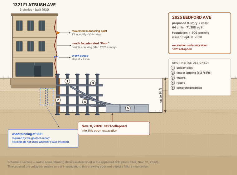
What the record does not establish is whether those protections were in place. It does not show whether 1321 was underpinned, which portions of the shoring system had been installed along its lot line by Nov. 11, or what the most recent movement, crack and vibration readings were. The support-of-excavation filing also required special inspection of sheeting, shoring and bracing; DOB NOW listed that category as identified but not certified as of Nov. 12. That status does not prove inspections were not performed — only that the requirement had not been certified as complete in the system.
The complaint after the collapse
An anonymous complaint filed the night of the collapse alleged that a subcontractor “may have excavated too much of the area along the neighboring foundation at once.” The complainant said the approved drawings showed a cut about 8 feet below the adjacent property grade with a 45-degree slope, and asked whether that slope had been maintained, whether stepped footings had been excavated in the required sequence, and how the contractor had accounted for sandy soil and high groundwater. The Buildings Department is investigating. The complaint is an allegation, not a finding.
The mayor said five entities are associated with the site and ordered a sweep of about 100 other sites tied to the companies involved. The Brooklyn district attorney’s office is also involved. The city issued a stop-work order at the site after the collapse.
Separately, CBS News reported 98 open housing violations at 1321, ranging from bedbugs to leaks. Those are housing-maintenance records, not a structural assessment, and they do not establish that the building was unsound. The owner in the parcel record, Isolag Realty Corp, is the same owner named in those reports.
What the file does not explain
The records support a few conclusions and leave the central one open.
They show a demolition that was cited twice, corrected, and signed off. They show a new-building application whose scope changed from three stories to nine while the main application remained in Objections. They show foundation and excavation permits issued for the larger scheme, a preconstruction survey that rated the wall facing the dig “Poor,” and a shoring and monitoring plan that was detailed on paper. They do not show whether the plan matched the field on Nov. 11.
For anyone who works with permit data, the case is a reminder that a permit is not a single fact. It is a version of a project, with a filing date, an approval date, an issuance date, a scope and a set of subplans that can move on different tracks. Joining those records to parcels is how you find the site. Reading the versions is how you see the story.
The investigation will determine what happened. The paper trail explains why so many people are asking.
Sources and method
Parcel and footprint records come from the landstats parcel layer; parcel IDs and dimensions were checked against the parcel geometry. Permit and enforcement records come from the buildstats.com database, which is sourced from NYC Open Data: DOB NOW Job Application Filings (w9ak-ipjd), DOB NOW Approved Permits (rbx6-tga4), ECB Violations (6bgk-3dad) and DOB Complaints (eabe-havv). Legacy BIS job filings (ic3t-wcy2) were checked for an earlier new-building filing; the extract we queried did not contain a separate approved three-story new-building permit.
Figures are schematic and are not surveys. The collapse cause remains under investigation; nothing here is a finding of fault.